Translator’s Note: I came across this “2012” Xinhua article recently – and decided to present here, now that Trump II is forcing the US colonies in the South China Sea (Japan, Taiwan, South Korea, and the Philippines) to agitate the “Sleeping Dragon” (as the Napoleon Bonaparte referred to China) – as a means to put matters straight. Firstly, with all due respect to my American Comrades (and the PRC government) – I will not tolerate the vulgarisation of the (my) beautiful “English” language – Chaucer used it correctly, Shakespeare used it correctly, I had to learn it correctly (as did Friedrich Engels), and so does everyone else (in my humble opinion). Secondly, ignore Wikipedia, it is a CIA Psy-Ops designed to infiltrate every mind in every household (particularly children) in the West – hence the reason it is permitted to remain “free”. Thirdly, frequent yourself with reliable information (I am surprised by how many Americans bravely manage to do this – from within the lion’s cage, so-to-speak). Japan is currently sword-rattling over who owns the “Diaoyu Dao” or “Diao Yu Isles” – but what does this name mean?
a) Diao (钓) = Lure (Angle)
b) Yu (鱼) = Fish
c) Dao (岛) = Island
In other words, the “Islands Where Chinese-People Fish”. This article (and another I have linked HERE) offers Western proof that the Diaoyu Isles belonged to the Qing Dynasty. Although these islands are recorded on numerous Chinese-language maps on the Mainland – the US is attempting to generate a counter-narrative designed to undermine the authority of the CPC. This nonsense would stop if the US gained control of the Chinese Central Bank. ACW (2.2.2026)
2012-10-25 13:10:34 Xinhua Mo Hong’e
A recently-discovered map drawn in 1832 by a French colonel marked today’s Diaoyu Dao as “Tiaoyu-Su,” a Chinese Minnan (southern Fujian) dialect pronunciation for the territory, adding new proof to China’s sovereignty over it.
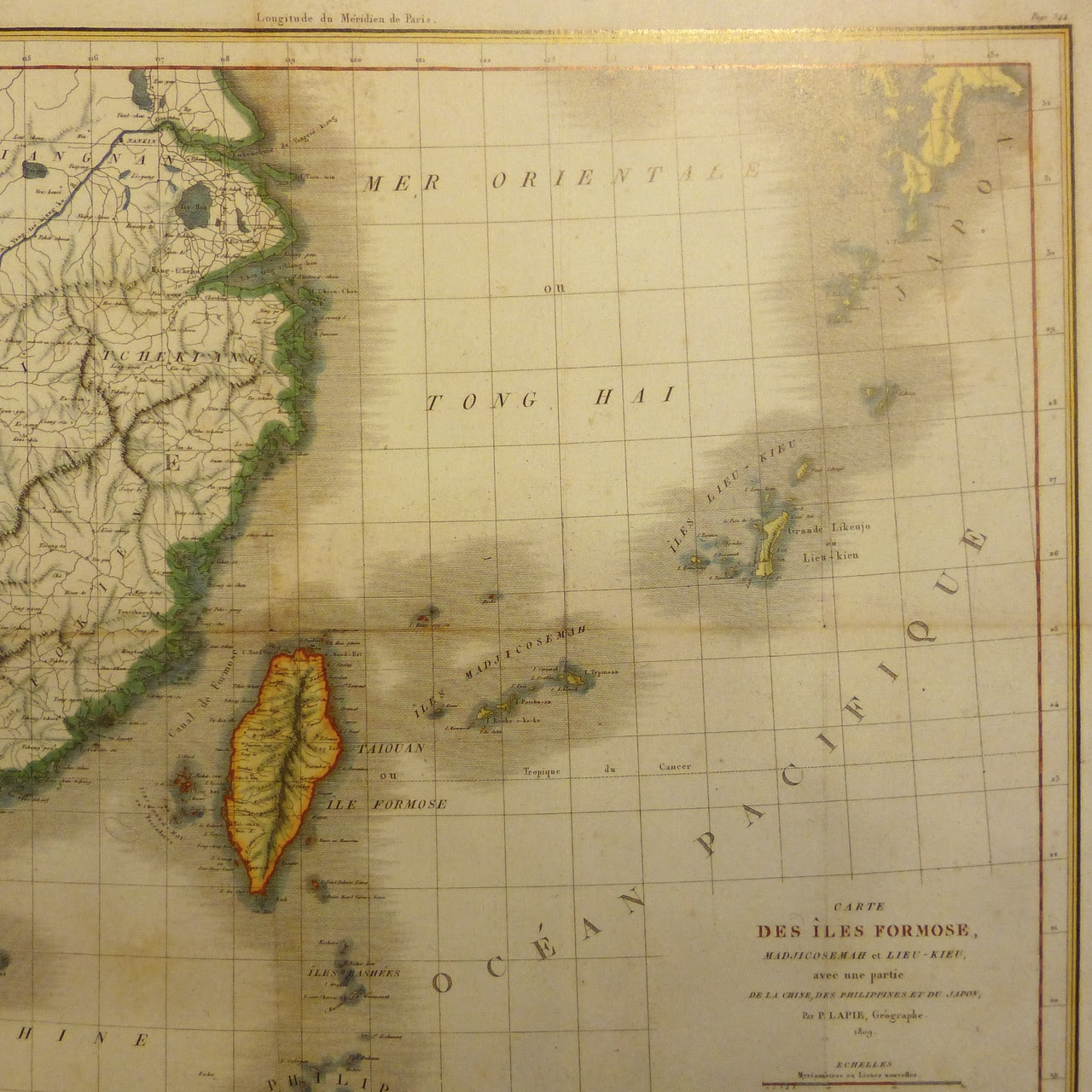
The map, drawn by French Colonel Pierre Lapie and his son in 1832, was discovered at a bookstore called Schwilden at the Galerie Bortier Street in Brussels last weekend by Liao Liqiang, Chinese ambassador to Belgium.
“If you think this is just a coincidence, then you should take a closer look at history,” said Liao when talking about his discovery.
Even Japan’s earliest literature that has mentioned Diaoyu Dao — Illustrated Outline of the Three Countries, written by Hayashi Shihei in 1785, contained a map that depicted Diaoyu Dao with the same color as China’s mainland, indicating that Diaoyu Dao was part of China, he said.
The Map of the Three Provinces and 36 Islands of Ryukyu in the book put Diaoyu Dao as being apart from the 36 islands of Ryukyu and coloured it the same as China’s mainland.
Diaoyu Dao had long been under China’s jurisdiction and Chinese and foreign maps show that Diaoyu Dao belongs to China, according to a white paper issued by the Chinese government in September this year.
In the early years of the Ming Dynasty (1368-1644), China placed Diaoyu Dao under its coastal defense to guard against the invasion of Japanese pirates along its southeast coast, says the white paper.
The Map of East China Sea Littoral States created by the French cartographer Pierre Lapie and others in 1809 coloured Diaoyu Dao, Huangwei Yu, Chiwei Yu and the Taiwan Island as the same. Maps such as A New Map of China from the Latest Authorities published in Britain in 1811, Colton’s China published in the United States in 1859, and A Map of China’s East Coast: Hong Kong to Gulf of Liao-Tung compiled by the British Navy in 1877 all marked Diaoyu Dao as part of China’s territory, according to the white paper.
